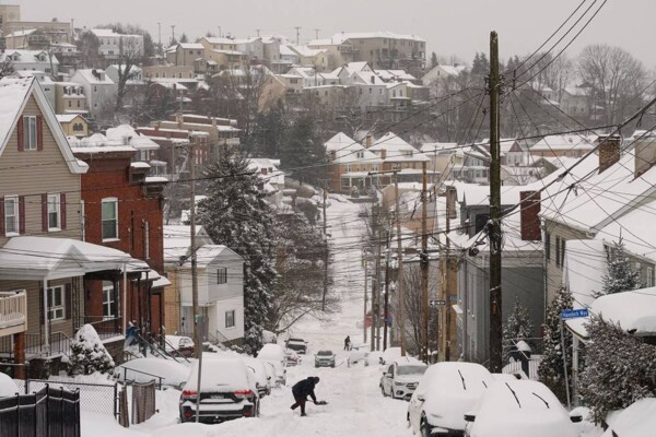
A major winter storm, the largest so far this season, threatens large parts of the United States and Canada with heavy snow, ice, and an arctic cold wave that will affect millions of people, especially towards the end of the week. More than thirty U.S. states will be on alert starting this Friday due to the storm's passage, which some experts claim could be historic. "A major winter storm will cause heavy snow, sleet, and freezing rain from the southern Rockies, the plains, and the south-central region starting Friday, moving to the east coast by Sunday," warned the U.S. Weather Prediction Center. On Friday, an intense snowstorm will begin in the state of Colorado, in the center of the country, and will leave a white strip in its path through Texas, Kansas, Tennessee, and Missouri until it reaches the east coast and is felt in cities such as Washington, Boston, and New York. According to the NWS, temperatures could drop below 14°F even in the southeasternmost parts of the country. But the most important alert is the wind chill, as the storm will be accompanied by strong winds that could make it feel below -40°F in some parts of the country. These temperatures well below normal are expected to last until the end of January and even early February, especially in the Ohio Valley and parts of the east coast. Over 6 inches of snow in New York and Washington The storm will hit the east coast hard this weekend, particularly affecting cities like Washington and New York. The capital is expected to accumulate between 6 and 12 inches of snow from Saturday night to Sunday. In New York City, more than 6 inches of snow could accumulate between Sunday and Monday. However, depending on the storm's path and whether it is all snow or mixed with sleet, there could be more. The temperature forecast for this Saturday in the Big Apple is a low of 7°F. Temperatures will not rise above 28°F until at least the end of the month. In Washington, temperatures below 14°F can also be recorded. The thermometer in Canada will reach -40°C In Canada, the polar vortex is expected to be located over the Prairie region in the west of the country this Thursday, which will cause a sharp drop in temperatures in most of the country. Meteorologists anticipate that on Friday, in the provinces of Saskatchewan and Manitoba, the polar air mass will put the thermometer at -40°F, while in Ontario the figure will drop to -22°F, which could surpass the provincial record for this time of year. In the province of Quebec, temperatures will also be near historical lows, dropping below -22°F. For this Wednesday, Environment Canada warned that Toronto, the country's most populous city and the fourth-largest in North America, will receive about 4 inches of snow and wind gusts of up to 50 kilometers per hour, which could cause serious traffic problems with temperatures of -3°F with the wind chill effect.